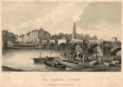
The River Dart is navigable from Dartmouth, where it flows into the sea, to its tidal limit at the weir on the northern edge of Totnes. Much of the town's early prosperity was underpinned by the use of the Dart as a trade route, especially for the export of woolen cloth in Elizabethan times and before.

The lithograph depicts the old Totnes bridge in 1825. The sturdy structure we see today is the new bridge designed and built by the Devon architect Charles Fowler in 1828.
The part of the town on the east bank of the Dart is known as Bridgetown. This used to be a borough in its own right, but was incorporated into the Totnes borough in 1835. The approach to Totnes from the Bridgetown side is described in "The route book of Devon: a guide for the stranger and tourist", Besley, Exeter 1846:

No longer is the Dart used to transport goods to and from Totnes. The former warehouses along the river in The Plains have been converted to upmarket residences, shops, or restaurants. These warehouses were still very much in use as such in the 1940s as can be seen in the old photo.
There used to be a paddle steamer service running to and from Dartmouth to the Totnes Steamer Quay. Today there is still a popular pleasure boat service from Totnes to Dartmouth and back from April through October, providing an opportunity to enjoy the spectacular scenery in what is perhaps the most beautiful stretch of river in the country.
This undated photo shows the Heart's Content and its passengers leaving Totnes, with the Steam Packet Inn in the background. The modern day craft are powered by marine diesel.

A pleasant feature of the riverside scene is Vire island, named after the French town twinned with Totnes. It is a narrow, tree lined stretch of parkland with full public access, sitting snugly between the town and the main flow of the river. A narrow channel of water divides the island from The Plains.
