")
With abundant rainfall soaked up by its upland mires, Dartmoor provides a convenient repository of gravity-fed water for the coastal population centres of Devon. Indeed, Dartmoor was the source of one the first public water delivery systems in the country: Drake's Leat, a 17 mile channel from a weir on the Meavy near Sheepstor running across Roborough Down, began supplying water to the citizens of Plymouth in 1591. This leat, augmented by the longer Devonport leat completed in the 1790s, were to serve Plymouth's water needs for three hundred years. By the 1880s the leats were proving inadequate due to excessive leakage, and were prone to blockage by impacted snow and ice as after the great blizzard of 1891.
It was agreed that Plymouth needed to be supplied by a large impounding reservoir situated on the moor from which water would be piped to Roborough reservoir to the north of the city. The location for the reservoir became a bone of contention leading to the so-called "Battle of the Sites" between Headweir on the Meavy at a point where the leat was drawn from the river and Harter Brook, 2½ miles up the Meavy Valley. This dispute rumbled on for several years. In the end, Headweir won the day, and Burrator Reservoir became operational in 1894. The dam was raised and widened in 1928 to increase the yield to 10 million gallons per day.
")

The first impounding Dartmoor reservoirs had been built earlier in the south-eastern fringes to supply the expanding coastal resort of Torquay; the first of these was Tottiford, completed in 1861, and the nearby Kennick reservoir dates from 1884. Paignton was the next town to claim its share of Dartmoor's bountiful waters with the damming of Venford Brook on Holne Moor in 1907 to form Venford reservoir. Torquay had its supply augmented that year by a third reservoir near Tottiford, and yet again when permission was granted in 1934 for a dam at Fernworthy. Building work was interrupted there by the outbreak of World War II, but it was completed by 1942.
The immediate postwar years saw changes in the administration of Devon's water resources. The existing localized water suppliers were amalgamated to create public Water Boards which in 1973 became part of the South West Water Authority covering the whole of South-West England.
The next Dartmoor reservoir to be approved was created by the building of a dam across the River Avon in South Dartmoor in a project managed by the newly formed South Devon Water Board. A certain amount of controversy surrounded the choice of site once again, but this was nothing like the furore that broke out when Meldon was chosen. The Avon Dam was first mooted in 1948 before the inauguration of the Water Board, and an enquiry into the draft Water Order was held the following year to which, anomalously, the planning authority had not been invited. This came to light too late to prevent government approval in 1950, the year before Dartmoor was granted National Park status. Arguments continued about the precise location of the dam, with particular concerns raised about the fate of the many antiquities in the area. Work finally began in 1954 and the reservoir began supplying the communities of South Devon in 1957.
The granting of National Park status to Dartmoor in 1951 heightened expectations that schemes to harness its resources that had an adverse impact on the landscape would be blocked in future. When the North Devon Water Board announced in 1962 that a new reservoir was required for its southern division, and disclosed that their favoured location for a dam was within the park on the West Okement at Meldon there were immediate objections from the planning authority and amenity organizations, both local and national. In the vanguard was the Dartmoor Preservation Association(DPA), founded in the 1880s initially to combat unlawful enclosure of common land, it soon expanded its remit to include protection of Dartmoor's landscape and antiquities from intrusive and destructive development. The moor had become more accessible with the opening of new railway lines through the towns on the perimeter, and it had become a popular destination for the intrepid tourist for the first time.
Before outlining the twists and turns in the protracted campaign to block the building of the Meldon Dam, the next section attempts to give a visual impression of the charm of the Meldon valley, illustrating why the proposal to 'drown' it became a cause célèbre to many despite the beautiful upper reaches of the valley being unaffected by the damming of the river.


The burbling and gurgling of the waters of the upper West Okement as it cascades down the winding channel carved between the surrounding hills is a pleasure to hear and to behold.
This extract from a traveller's journal published in 1830 describes the surrounding scenery:
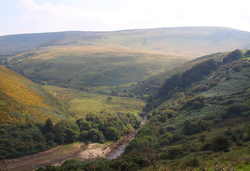
The West Okement valley upstream from here remains as beautiful as ever, undefiled by the the Meldon Dam that impounds the waters of the river downstream.


The emotional reaction to the building of the dam by its opponents gave the impression that the whole valley had been devastated, whereas in reality it was only the valley floor or gorge as far as Vellake Corner that was lost to posterity. This cri de couer is from first page of the Dartmoor Preservation Association's 62 page booklet The Meldon Story, published not long after the reservoir was filled:
Despite its partisan stance, this text is a valuable source of detailed information on the thwarted attempts to block this project from its inception in 1962 until construction work began in 1970.

